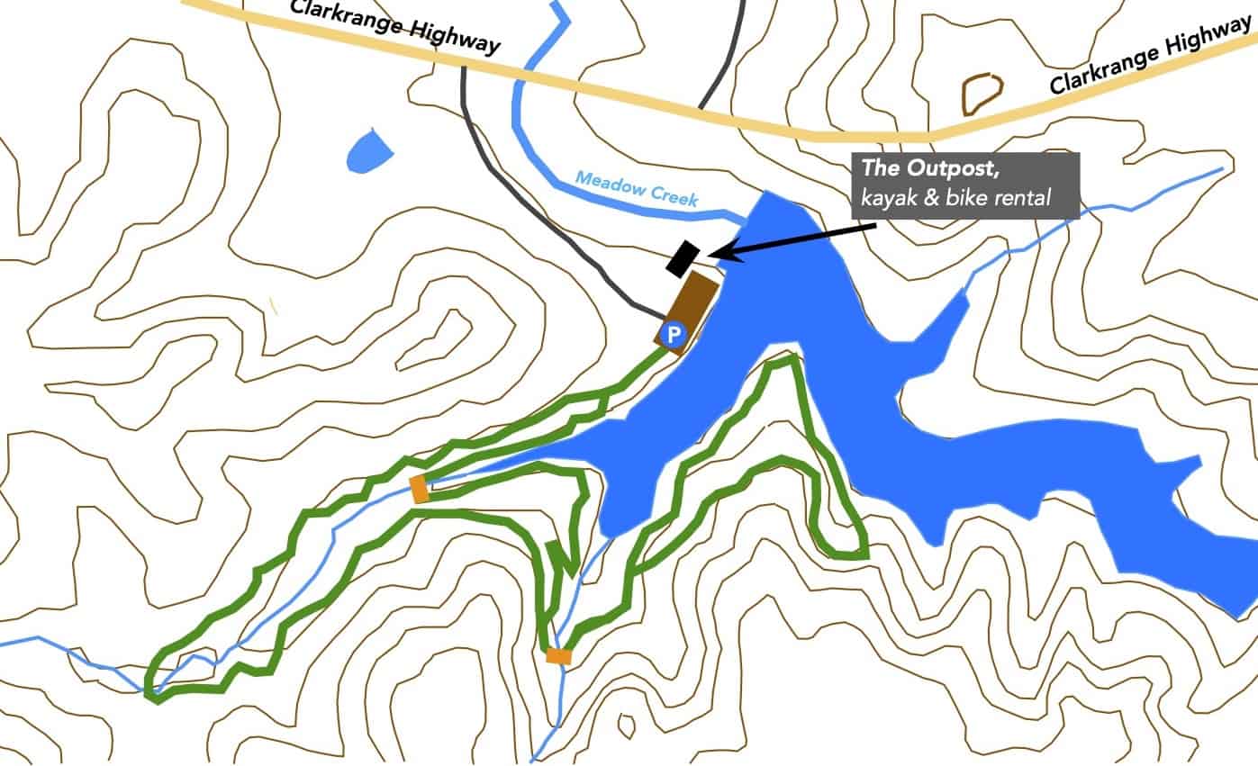
Marathon Trails & Maps

Welcome to the Cumberland County Hiking Marathon. As you hike these trails you will enjoy a wide variety of terrain and geographical features. We hope this marathon takes you places that you would not normally go and that you have positive experiences along the way. We hope you enjoy hiking these trails but please stay on the trail when hiking and respect private property in residential communities. Carry plenty of water at all times, use bug-spray and watch your step – it is easy to twist an ankle on rocks and tree roots. Pets are permitted on all trails but please pick up after your dog if it fouls the trail-bed. The information on this page is for hikers who are doing the Full Marathon (26.2 miles) or the Half Marathon (13.1 miles.)

Fairfield Glade Trails

1. Overlook Trail

Description

This is a hiker favorite and annual standard. The trail was extended in 2022/2023 to the west below the parking lot. This new section has some remarkable rockwork for you to enjoy. You will find the section along Daddy’s Creek peaceful and relaxing. Walking alongside water is always interesting. 

Driving Directions
From the Peavine Road/Stonehenge Drive junction, take Peavine going east for half a mile. Turn right onto Westchester drive. After 3.0 miles, just after passing Dorchester Golf Club, turn left onto Windsor Road. Take the second right onto Wimberley Road then immediately turn left onto the gravel road. This road ends at the Overlook parking area and trailhead. After parking your vehicle and enjoying the views from the overlook enter the trail on the left.

2. Fairfield Glade Seven Bridges Trail

Description
This trail begins at the Methodist Church on Westchester Drive. It is a pleasant walk through the woods by a number of streams with, you have guessed it, seven bridges. As you can see on the map it is a lollipop configuration where you walk half a mile up the stem and then a one-mile loop before returning to the trailhead along the stem.

Driving Directions
From the junction of Peavine Road and Stonehenge Drive head east along Peavine Road for 0.5 miles. Turn right on to Westchester. Head south for 0.7 miles and pull into the first parking lot of the Methodist Church where trail parking is permitted. Cross the road to the trail head.

3. Fairfield Glade Green Loop

Description
This loop takes you on three trails: the McGinnis Trail, the Good Samaritan Trail and the Canyon Trail. Most of the hike is on dirt trails in the woods but there is  a short section on a paved sidewalk. The trail can be hiked in either the clockwise or counter-clockwise direction.

Driving Directions

From the junction of Peavine Road and Stonehenge Drive, take Peavine Road east for half a mile and turn left on to Catoosa Boulevard. After 2.8 miles, having passed the Good Samaritan facility, turn into parking area on your right, marked with a “Nature Trails” sign. 

4. Fairfield Glade Glastowbury Trail

Description

This trail begins at the boat ramp at Lake Glastowbury. It is not the easiest trailhead to find but worth the effort! This one-mile trail offers some nice views across the lake but most of the trail is a woodland walk. 


Driving Directions
From St George Drive take Manchester Road then turn left onto Lafayette Lane. Just before entering the condo complex, turn right onto Hunterwood Lane (Signed to the boat-launch). Turn left to the boat-launch and park at the trailhead.

5. Fairfield Glade Stonehenge Trail

Description
This is a 1.5-mile linear trail so the round-trip distance is 3.0 miles. The half-way point is the Heatherhurst golf club. The highest point of the trail is around the Lynhurst Drive area. Consequently it is a steady uphill climb from either end of the trail.

Driving Directions
From the junction of Peavine Road and Stonehenge Drive, head north on Stonehenge Drive for 0.9 mile to the trail-head parking lot, on the left, at the corner of Kingsboro Drive.

Business Startup_expand

Cumberland County Trails

6. Byrd Creek Trail, Cumberland Mountain State Park

Description

The normal Byrd Creek Trail goes up one side of the creek and returns on the other side. However, due to poor condition of the trail on the east bank of the creek, we are recommending hiking up the west bank of the creek from the dam and then turning around and hiking back on the same side of the creek. Start at the dam and hike along the creek on the Plateau Trail which becomes the Byrd Creek Trail. Follow the red arrows. When you reach the Boy Scout covered bridge, with the STOP sign, turn around and retrace your steps, following the red arrows once again.

NOTE: Although the full Plateau Trail is shown on the map, the section of the trail close by the creek is rather challenging with a steep climb by the dam.  We recommend that hikers follow the red arrows and take the “high road” away from the creek. A scramble down below the dam is worthwhile to view the cascading water…but it is a challenge.

Driving Directions
The Cumberland Mountain State Park is very well known and there are plenty of road signs directing you to the park, which is about four miles south east of Crossville on Highway 127. There is plenty of parking in the park but please do not park in the restaurant parking lot as that gets very busy at times. We suggest you park in the section of the parking lot, off to the side, on the right as you face the restaurant. If that lot is full park near the kayak boat dock behind the restaurant and walk over to the trail-head by the dam. 

7. Soldier’s Beach Trail, Meadow Park, Crossville

Note: Meadow Park is south of Crossville and should not be confused with Meadow Creek Park near Monterey.

Description
It is a very pretty trail in Meadow Park with not many uphill sections to be negotiated and many views across the lake. The trail does pass close to the lakeshore so children do need to be supervised. The trail passes by Soldier’s Beach a popular picnic and swimming area for families

Driving Directions
To get to Meadow Park take Lantana Road, Highway 101, south out of Crossville. After about 3.5 miles, go straight through the lights where Highway 282 turns off for Lake Tansi. The road narrows from four lanes down to two lanes. After another mile turn right on to City Lake Road. There is a large Meadow Park sign on the corner. Follow City Lake Road for 1.4 miles and it dead-ends at the park marina and office.  Enjoy the views across the lake, and maybe use the restrooms at the campsite.

8. Uplands Village Trails, Pleasant Hill

Description

The Uplands Village Trails are three trails with their trail-heads within walking distance of each other.

The Lake Alice Trail has been on the marathon a few times in the past and is a pleasant hike around the lake. This year we are adding the Frey Branch Trail which is a one-mile trail through some steep and rocky terrain in the woods. The Lake Laura ADA Trail is a very short trail.

NOTE: When walking on West Lake Road between trails or parking, walk on the shoulder on the west side of West Lake. The shoulder is wider there and safer around the blind curve.

Driving Directions

The Lake Alice Trail is in Uplands Village, Pleasant Hill.  Take the Sparta highway from Crossville for 10 miles then, shortly after passing a gas station on the left, take the right turn on East Main Street into the village. Pass the Elementary School and a short distance later turn right on to West Lake Road. After about half a mile pull over to the left onto Yonside Drive and immediately left again into the gravel trailhead parking from where you can access all three trails.

NOTE: Yonside is a one way street. However it is acceptable to enter Yonside the wrong way for the very short distance to the parking lot.

9. Airport North Loop, Crossville

Description

NOTE: There has been significant damage to this trail from recent strong winds. Negotiate downed trees carefully.

This is Crossville’s newest trail, completed shortly before the 2023 marathon (…so there may be more trip-hazards  than usual on this trail.) The trailhead is a newly constructed parking lot on Earl Jones Road. The trail is lollipop design with a 0.2-mile stem and a 1.9-mile loop. This is an interesting trail that takes you through a variety of terrain and vegetation, including multiple views of the airport activities. There is nothing quite like it anywhere else in Crossville. (In 2024 we hope to add a second trail on this property, the Airport South Loop, a 2.5-mile trail that will use the same trailhead parking lot but will be mainly south of the lake.) I have no doubt that you will enjoy hiking this trail.

Driving Directions:

From Crossville, take Sparta Highway from the Kroger store. Head west for three miles, past the airport terminal building and runway. At the end of the runway turn left, just before the recycling center and almost immediately turn left again on to Earl Jones Road. After about a quarter of a mile you will see the trailhead parking lot on the left.

10. Gateway Trail, Meadow Creek Park, Monterey

Note: Meadow Creek Park is near Monterey and should not be confused with Meadow Park near Crossville

Description

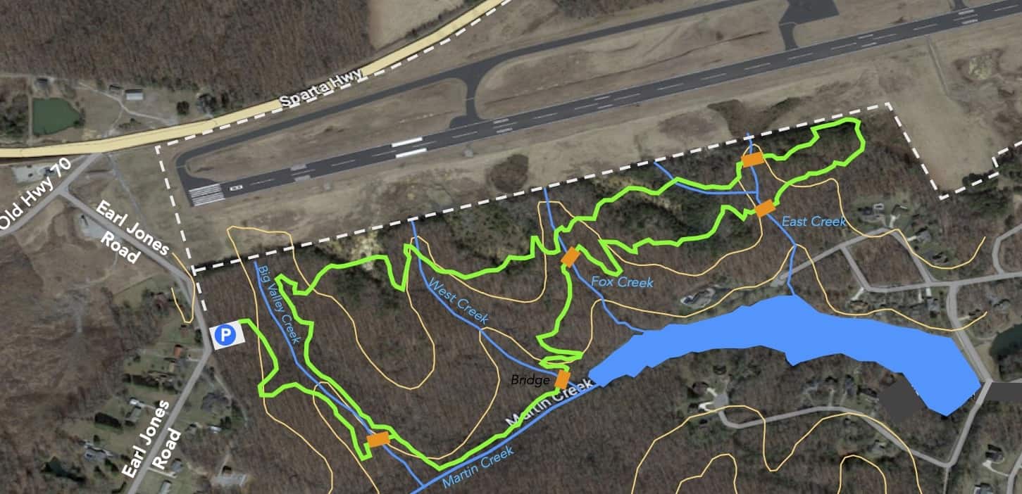
Meadow Creek Park is a multi-use recreational park that is being developed, by the town of Monterey for mountain biking, hiking, fishing, kayaking, etc. There are many trails in the park but they are primarily biking trails but hikers are welcomed. A trail all around the lake is under construction. 

NOTE: Take care and watch out for mountain bike riders while on the trail…especially if you have a dog on a leash.

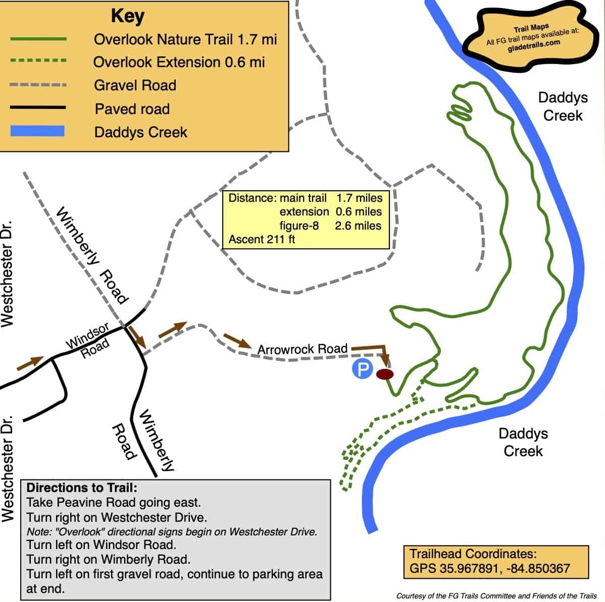
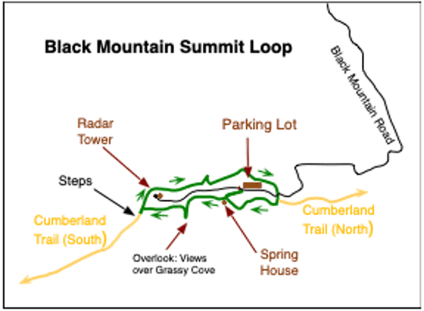
The Hiking Marathon Gateway Trail is one of the trails that is an enjoyable hike with a short section around halfway that is rather steep. Navigate carefully by following the many red arrows

Driving Directions

From Crossville, take Highway 70 North to Monterey. In Monterey turn right on to South Holly Street for four or five blocks before turning right on to East Commercial Street (which is Monterey’s  “Main St.” where you can find a few stores and restaurants).Stay on E Commercial St, which becomes Clark Range Highway, for five miles. You will see the entrance to Meadow Creek Park on the right. Go to the end of the gravel road, about a third of a mile, to the trailhead parking lot that is shared with fishermen and kayakers

11 Black Mountain Summit Loop, Cumberland Trail

Description

After parking the car, follow the signs to the Main Trail and the South Overlook. After enjoying the views at the overlook return to the Main Trail and head south along this section of the Cumberland Trail. Although it is not required for the marathon, you can take the staircase down off the summit if you want to admire the rock formations, then back up the stairs and turn left onto the loop trail to the northern overlook. Continue along the loop trail, crossing over the access road. Note where the main, Cumberland Trail branches off the left but remain on the loop trail and return to the parking lot. The trails in the park pass close to steep drop-offs in many places so children should be supervised.

Driving Directions
Take Bat Town Road south from the Crab Orchard exit from I-140, Exit 329. After about two miles turn left onto Owl Roost Road where it is signed to the Justin P Wilson State Park. Take Owl Roost Road and Black Mountain Road for three miles to the parking lot at the summit of the mountain. Drive carefully as it is a single lane road with places to pull off for passing.