Welcome to the Cumberland County Hiking Marathon 10K Challenge. As you hike these trails you will enjoy paved trails with easy gradients. The purpose of this challenge is to provide an interesting set of trails that can be enjoyed by those who find the marathon trails just too difficult to negotiate. We hope this challenge takes you places that you would not normally go and that you have positive experiences along the way.
We hope you enjoy hiking these trails but please stay on the trail when hiking and respect private property in residential communities. Carry plenty of water at all times, use bug-spray and watch your step – it is easy to twist an ankle on rocks and tree roots. Leashed pets are permitted on all trails but please pick up after your dog if it fouls the trail-bed.
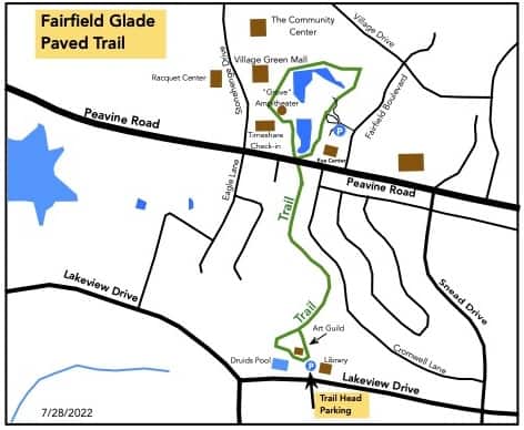
This is a mostly shaded 1.9 mile lollypop trail that goes thru the woods to the Central Area. Along the way you will see all kinds of birds and other wildlife. Deer are frequently seen here. Don’t miss the Whale Watch opportunity along the way. After passing under Peavine Road you will go around two lakes: Mirror Lake and the lower lake. At the far end you will come to the Wyndham Timeshares where you will begin to return toward the tunnel. You will pass The Grove stage and will soon come to where you will begin the backtrack thru the tunnel. At the Sculpture Garden you will turn right to enjoy the many sculptures before you return to the trailhead.
Trail Directions:
Begin at the Fairfield Glade Library. The trailhead is at the parking lot near the mini golf course
Continue on the trail until you come to a T-junction. Turn right
Continue until you pass thru the tunnel that goes under Peavine Rd then turn right at the T at Mirror Lake
Follow the trail around the lake. At the parking lot behind the church continue straight
The trail picks up again on the opposite side of the parking lot
Continue thru the next parking lot – Do NOT turn left to cross the bridge by the lake
The trail picks up again on the far right side of the parking lot
Continue on this trail staying to the left at the Wyndham Timeshares and follow close to the lake. At the T-junction, turn left
Continue until you backtrack through the tunnel
When you come to the Sculpture Garden, turn right and enjoy .1 miles of sculptures before you return to the trailhead
Driving Directions
Approaching Fairfield Glade from Crossville turn right onto Snead Drive just after Weigel’s gas station. Take third turn on the left onto Lake View Drive.
Just Past the Druid Hills golf Club turn left at the stop sign. Turn left into the Fairfield Glade Library parking lot.
The street address of the library is 455 Lakeview Drive, Crossville, TN 38558
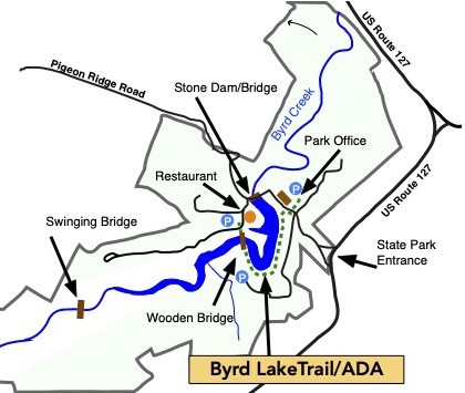
2. Cumberland Mountain State Park: Storybook Trail/ADA
Distance: 1.5 miles (2.4 Km)
Rating: Easy
Trailhead GPS Coordinates: 35.899421, -85.000321
Description
This is a mostly shaded in and out trail. Before you start the hike you might enjoy a visit to the free Civil Conservation Corps, CCC, Museum and get a little more education on the history of the Cumberland Mountain State Park.
Head down to the boat dock and cross the wooden bridge. Along the trail you will see all kinds of birds and other wildlife. You will enjoy many great views of historic Byrd Lake. There are even nice restrooms at both ends of the trail: in the museum building and in the park office.
Stop when you reach the road by the park office, turn and retrace your steps. On your return trip you will get a different perspective of the lake. Be sure to get some photos of what is likely the most photographed bridge in Tennessee. It is the beautiful stone bridge that was built by the CCC in the early 1930’s as part of the New Deal.
Driving Directions
The Cumberland Mountain State Park is very well known and there are plenty of road signs directing you to the park, which is about four miles south east of Crossville on Highway 127.
There is plenty of parking in the park but please do not park in the restaurant parking lot as that gets very busy at times. We suggest you park in the lot a little way from the restaurant as a courtesy to diners.
This is an easy 1.7 mile trail that is shaded for about ½ the hike. Along the hike you will see the Obed River, the failed G.E. Harrison and J. Ridley Mitchell Dam, the location of the closed Tennessee Central Railroad Trestle and Corridor, and many Bluebird houses.
Park in the second parking lot on the left (third entrance) after turning into the Obed River Park
Look for the sign marking the trailhead toward the left
Follow the paved trail along the river
In about a half mile the trail turns up the hill at the failed G.E. Harrison and J. Ridley Mitchell Dam
Continue up to the field and continue on the paved trail for about another quarter mile
Take the first paved trail to the right
From here you will hike the entire loop around the field to return to this intersection
The second time around the loop you will take the next right down the hill
Continue on the paved trail until you come to a parking lot
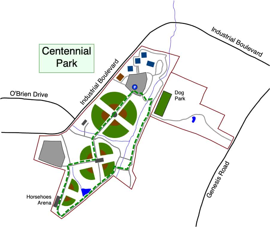
This is an easy 1.2 mile hike. It is mostly in the sun, so a morning hike is recommended. This hike will take you through and around the softball fields and past the horseshoe building. It then circles up past the dog parks and back to the parking lot.
Park in the parking lot close to the dog parks. The starting point is at the small plaza where 3 flags are displayed. This is also the same lot used for the pickleball courts.
The hike begins at the flags. Walk up the paved trail through the building and between the softball fields. Continue straight
At the crosswalk, continue straight toward the restrooms and horseshoe building
Just past there the trail begins to circle back
In an eighth mile or so, take a right across the bridge. At the T-junction take a left toward the dog parks
Follow the trail to the second dog park. Take the sharp left at the trash can to begin your return to the parking lot
Cross the bridge and follow the path up to the starting point parking lot
Driving Directions
Centennial Park is located on Industrial Boulevard.