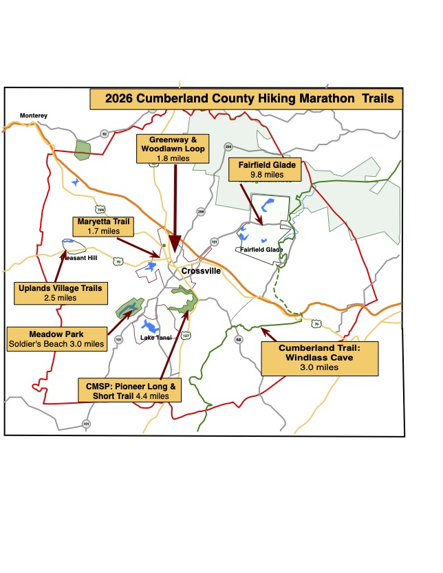
Marathon Trails & Maps
Welcome to the Cumberland County Hiking Marathon. As you hike these trails you will enjoy a wide variety of terrain and geographical features. We hope this marathon takes you places that you would not normally go and that you have positive experiences along the way. We hope you enjoy hiking these trails but please stay on the trail when hiking and respect private property in residential communities. Carry plenty of water at all times, use bug-spray and watch your step – it is easy to twist an ankle on rocks and tree roots. Pets are permitted on all trails but please pick up after your dog if it fouls the trail-bed. The information on this page is for hikers who are doing the Full Marathon (26.2 miles). Record your progress on the Log Sheet, either online or on paper (and submit online later.) Substituting other Marathon Trails is permitted: Hiking the FG Overlook Trail twice and not hiking the Cascade Trail is acceptable. Please log your completed trails online so that we have an accurate picture of everyone’s accomplishments with reduced work for our volunteers. For those who prefer the less strenuous walking on paved trails, once again we are offering a 10K Challenge. This consists of trails with a combined length of 10 kilometers (6.3 miles). There is a separate Trails Description Document and Log Sheet, and registration for the 10K Challenge. There is an activity program for kids under 12 years old as they hike the trails.
Latest version dated 24 August 2026.
We Use QR Codes
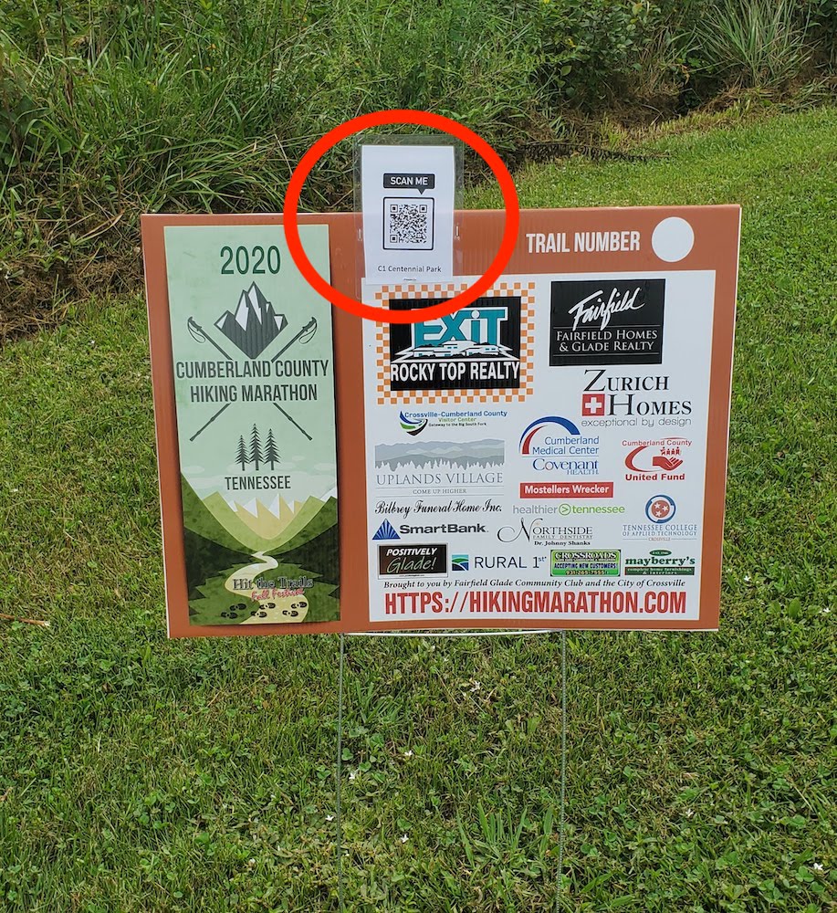
A QR code is a strange graphic consisting of black squares and dots. If you try to take a picture of a QR code with your phone it will offer to take you to a website. Accept the offer with our QR codes and you go straight to the appropriate trail map and description.
You will find the QR code at each trail-head attached to the top of one of the marathon signs. Snap a picture and bring up the trail map on your phone. It is as easy as that.

Fairfield Glade Trails
1. Overlook Trail, Fairfield Glade
- Distance: 2.3
- Rating: Moderate
- Trailhead GPS Coordinates: 35.967933, -84.850431
Driving Directions
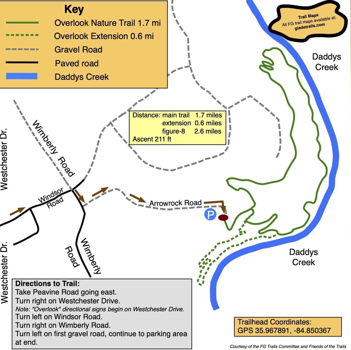
From the Peavine Road/Stonehenge Drive junction, take Peavine going east for half a mile. Turn right onto Westchester drive. After 3.0 miles, just after passing Dorchester Golf Club, turn left onto Windsor Road. Take the second right onto Wimberley Road then immediately turn left onto the gravel road. This road ends at the Overlook parking area and trailhead. After parking your vehicle and enjoying the views from the overlook enter the trail on the left.
Description
The Windsor Bluff Overlook Trail as it is formally called, is one of the most beloved hiking destinations in Fairfield Glade, Crossville, Tennessee, offering a perfect combination of scenic beauty, peaceful woodland surroundings, and an invigorating hiking experience.
From the overlook area, walk down the trail to the first junction where you can decide whether to go clockwise or counter clockwise around the 2.3 mile outer loop.
One of the trail highlights is its close connection to Daddy’s Creek. Throughout much of the hike, the soothing sound of flowing water accompanies visitors, creating a peaceful and relaxing atmosphere. In 2023, the trail was extended by 0.6 miles, adding a beautiful new section that showcases impressive rock work and provides even more scenic enjoyment for hikers.
Several benches are thoughtfully placed along the route, offering convenient spots to rest and take in the natural surroundings. A particularly inviting bench sits in front of a striking rock formation overlooking the creek, providing a wonderful place to pause and appreciate the beauty of both the rock features and the water below. Hikers will also encounter a wooden bridge that helps navigate one of the steeper sections of the trail, making the ascent and descent safer and more accessible.
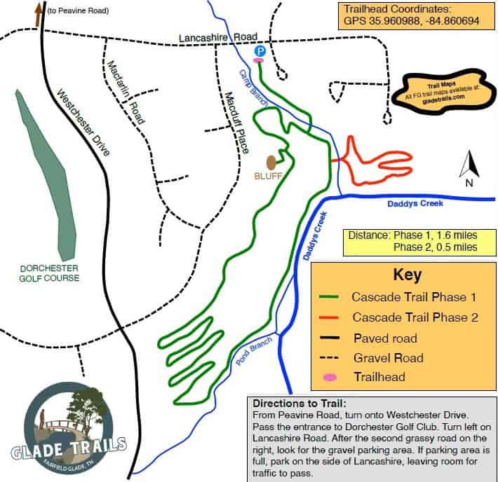
2. Cascade Trail, Fairfield Glade
- Distance: 2.3
- Rating: Moderate
- Trailhead GPS Coordinates: 35.961033, -84.860668
Driving Directions
From Peavine Road, turn onto Westchester Drive go 3.5 miles, passing the entrance to Dorchester Golf Club. Turn left on Lancashire Rd. (look for the Cascade Trail directional arrow). Proceed 0.3 miles to the third gravel/grass road on the right. Follow the sign to the gravel parking lot on the right. If the lot is full, park on the side of Lancashire Rd, leaving room for traffic to pass.
Description
The Cascade Trail officially opened in the Summer of 2025, is one of Fairfield Glade’s most scenic and rewarding hiking experiences, offering visitors a journey through the rugged natural beauty of the Cumberland Plateau. Winding through a peaceful forest of hardwoods and pines, the trail showcases impressive rock formations, towering sandstone outcrops, and picturesque views that change with the seasons.
Leave the parking lot and head down the long hill. At the bottom of the hill after crossing the bridge decide whether to turn right or left to hike counter-clockwise or clockwise around the main trail. If you turn left you will shortly come to junction with the extra loop (Phase 2). Enjoy this loop and then continue around the main trail.
One of the trail’s most memorable highlights is the bluff overlook, where hikers are treated to sweeping views of the surrounding landscape and the winding corridor of Daddy’s Creek below. Just beneath the bluff lies a unique feature known as “The Squeeze”, a narrow passage between massive rock formations that adds a sense of adventure and wonder to the hike. The dramatic cliffs, weathered stone formations, and shaded creek valley create a landscape that feels both wild and timeless.
As the trail follows the edge of the gorge, hikers can enjoy the sights and sounds of Daddy’s Creek, whose waters have helped shape the area’s remarkable geology over thousands of years. Whether you’re drawn by the stunning overlooks, fascinating rock features, abundant wildlife, or the peaceful beauty of the forest, the Cascade Trail offers an unforgettable outdoor experience and a deeper appreciation for the natural wonders of Fairfield Glade.
During autumn, the Cascade Trail becomes one of the most spectacular hiking destinations in the region. The forest comes alive with brilliant shades of red, orange, gold and crimson as hardwoods blanket the landscape in vibrant fall color. From the bluff overlook, hikers can enjoy sweeping views of the surrounding hillsides painted with the rich hues of the season. Fallen leaves carpet the trail, while the crisp air and warm sunlight create ideal conditions for hiking, photography, and enjoying the beauty of the Cumberland Plateau at its peak.
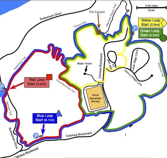
3. Green Loop, Fairfield Glade
- Distance: 4.2 miles
- Rating: Strenuous
- Trailhead GPS Coordinates: 36.031447, -84.850316
Driving Directions
From the junction of Peavine Road and Stonehenge Drive, take Peavine Road east for half a mile and turn left on to Catoosa Boulevard. After 2.8 miles, having passed The Preserve facility, turn into parking area on your right, marked with a “Nature Trails” sign.
Description
This loop takes you on three trails: the McGinnis Trail, the Good Samaritan Trail and the Canyon Trail. The McGinnis Trail has been extensively updated this year by the Fairfield Glade Trail Builders so you will experience some significant improvements. Most of the hike is on dirt trails in the woods but there is a short section on a paved sidewalk. The trail can be hiked in either the clockwise or counter-clockwise direction.
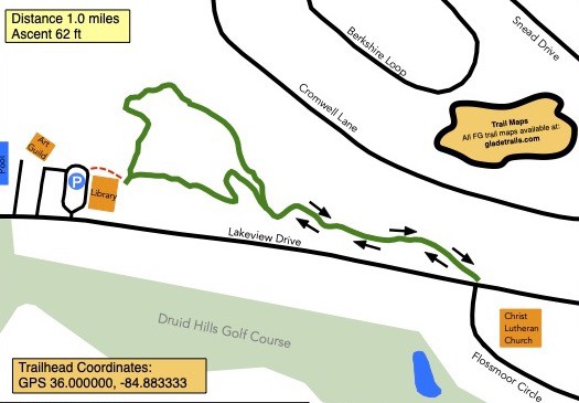
4. Library Trail, Fairfield Glade
- Distance: 1.0 miles
- Rating: Easy
- Trailhead GPS Coordinates: 36.000000, -84.883333
Driving Directions
From the junction of Peavine Road and Stonehenge Drive, take Peavine Road east for half a mile (away from I-40) to Snead Drive. Turn right on Snead. Travel about 0.5 miles to Lakeview Drive. Turn right on Lakeview. Travel about 0.5 miles to the Library building on the right.
Trailhead is located on the lower left side of the Library, near the restrooms.
Description
This is a “lollipop” trail with a loop and a stem.
Begin the trail by the lower level of the Fairfield Glade library and follow it to Lakeview Drive across the street from the Lutheran church. Turn around when you see the Marathon Stop sign and on the way back go right at the “Y”, go past the mini golf and around the paved Sculpture Trail and back to your vehicle.

Cumberland County Trails
5. Soldier's Beach Trail at Meadow Park
- Distance: 3.0 miles
- Rating: Easy
- Trailhead GPS Coordinates: 35.899123, -85.088388
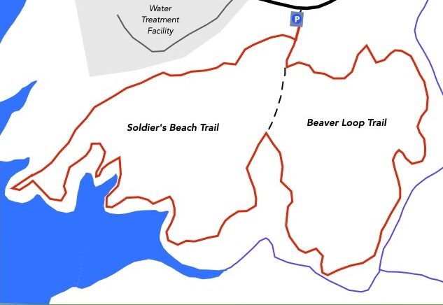
Note: The Beaver Loop section of this trail is under construction and will not be completed before September 1st. Use caution as trip hazards may still be there during the marathon.
Note: This is called Soldier’s Beach Trail because, during World War 2, German Prisoners of War from a camp in Crossville were used to build a recreational facility here for US Soldier’s families. You can learn more about the POW camp Here
Driving Directions
To get to Meadow Park take Lantana Road, Highway 101, south out of Crossville. After about 3.5 miles, go straight through the lights where Highway 282 turns off for Lake Tansi. The road narrows from four lanes down to two lanes. After another mile turn right on to City Lake Road. There is a large Meadow Park sign on the corner. The trail-head parking is about half a mile on the left but you might want to follow City Lake Road to where it dead-ends at the park marina and office. Enjoy the views across the lake, and maybe use the restrooms at the campsite. Feel free to stop in the office and say “Hi” to the park manager, then drive back up the entrance road 0.6 miles to the trail-head parking lot which will now be on the right hand side of the road.
Description
The Soldier’s Beach Trail offers visitors and hikers a peaceful lakeside escape where natural beauty, relaxation and outdoor recreation come together. Surrounded by scenic woodland views and the calming presence of the water, this trail creates the perfect setting for hikers, walkers, and nature lovers looking to enjoy the outdoors at a slower, more refreshing pace.
Beaver Loop is a new addition to the Soldier’s Beach Trail. Start off onto Soldier’s Beach Trail in a clockwise direction. After about 100 yards turn left onto the new Beaver Loop. Follow this trail for about 1.4 until it rejoins the Soldier’s Beach Trail. Turn left and follow the trail along the lake shore and eventually back to the parking lot.
As the trail winds through the area, visitors and hikers can experience beautiful shoreline scenery, gentle breezes and quiet moments that make it easy to relax and recharge. Whether you are taking a morning walk, enjoying an afternoon hike, or simply spending time in nature, the Soldier’s Beach Trail provides an excellent opportunity to improve physical fitness while supports mental wellness and reducing everyday stress. As the leaves change into rich shades of red, orange and yellow, the surrounding landscape transforms into a stunning natural masterpiece. Soldier’s Beach Trail in the fall is the perfect destination for visitors seeking beautiful scenery, fresh air, and a peaceful connection with nature.
6. Crossville Greenway & Woodlawn Loop
- Distance: 2.0 miles
- Rating: Easy
- Trailhead GPS Coordinates: 35.969254, -85.025517
Driving Directions
The trail-head is inside Centennial Park which is on Industrial Boulevard in Crossville. Enter the park at the Warner Complex entrance continue straight ahead around the loop past the dog park lot and turn right into the pickleball lot. Take the short road behind the pickleball courts and park in the few available parking spots. If no parking spots are available leave your vehicle in the large parking lot and walk to the trailhead.
Description
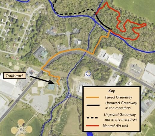
From the trail-head, take the paved trail to the edge of the park where the Greenway starts. Follow the Greenway, using the flashing lights to assist with crossing Industrial Boulevard. Continue past the TWRA office and Dentist office before turning into the woods and proceeding to the new steel bridge. Crossover the Little Obed River on the bridge where the paved trail ends. Turn left and follow the unpaved Greenway trail for a while before turning right on to the Woodlawn dirt trail. Follow this trail until it brings you back to the steel bridge where you rejoin the paved Greenway and return to the trail-head.
7. Maryetta Trail, Crossville
- Distance: 1.7 miles
- Rating: Moderate
- Trailhead GPS Coordinates:35.960250, -85.049983
Driving Directions
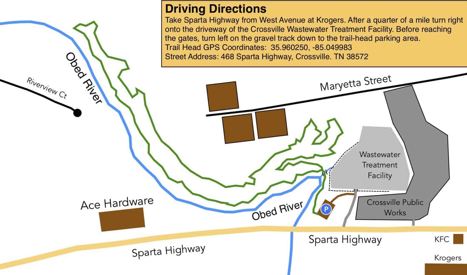
Take Sparta Highway from West Avenue at Krogers. After half a mile turn right onto the driveway of the Crossville Wastewater Treatment Facility. Before reaching the gates, turn left on the gravel track down to the trail-head parking area.
Description
It is a 1.7 mile “lollipop” trail in the woods pretty close to downtown Crossville. One leg of the loop is along the Obed River. The return is higher up the hillside. A negative of hiking this trail is that there can be an unpleasant odor from the Flowers Bakery wastewter processing facility along the upper leg of the trail.
8. Lake Alice Trail, Pleasant Hill
- Distance: 1.5 miles
- Rating: Easy
- Trailhead GPS Coordinates: 35.982601, -85.203931
NOTE: Yonside is a one-way street. However it is acceptable to enter Yonside the wrong way for the very short distance to the parking lot.
Driving Directions
The Lake Alice Trail is in Uplands Village, Pleasant Hill. Take the Sparta highway from Crossville for 10 miles then, shortly after passing a gas station on the left, take the right turn on East Main Street into the village. Pass the Elementary School and a short distance later turn right on to West Lake Road. After about half a mile turn left onto Yonside Drive and immediately left again into the gravel trailhead parking for the ADA Trail, from whch you can access the Lake Alice Trail.
Description
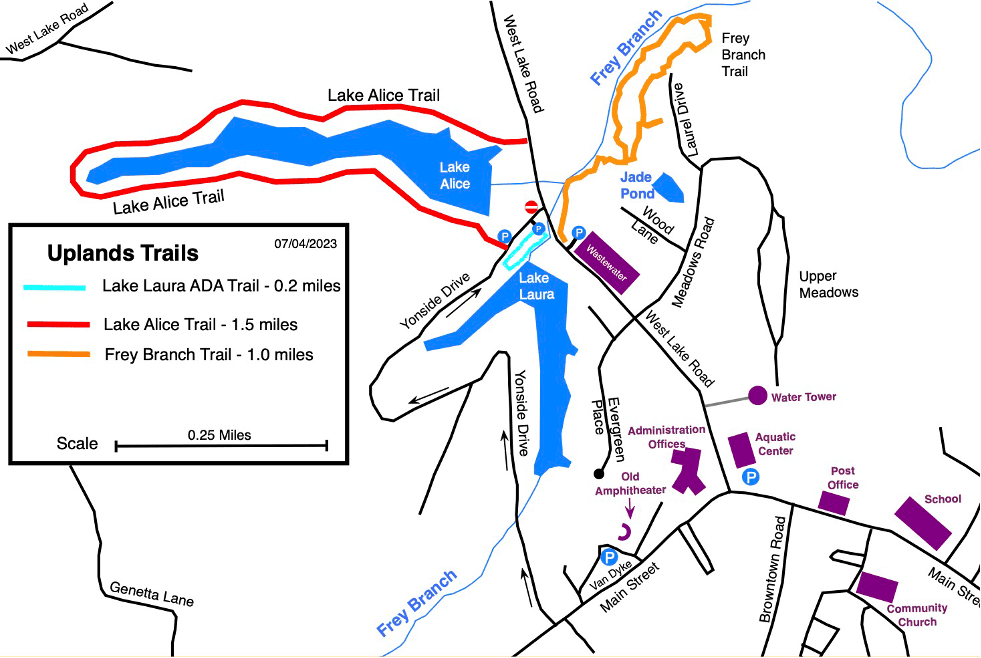
This is a nice walk through the woods with lake views. From the parking lot, walk up Yonside Drive a short distance turning right where the Lake Alice Trail kiosk is. Follow the trail markers in a clockwise direction around Lake Alice until it ends at West Lake Road where you turn right for a short walk back to the parking. This trail has had many improvements over the last few years adding bridges, boardwalks, trailhead kiosks, benches and 911 markers.
9. Frey Branch Trail, Pleasant Hill
- Distance: 1.0 miles
- Rating: Moderate
- Trailhead GPS Coordinates: 35.982601, -85.203931
NOTE: Yonside is a one-way street. However it is acceptable to enter Yonside the wrong way for the very short distance to the parking lot.
Driving Directions
The Frey Branch Trail is in Uplands Village, Pleasant Hill. Take the Sparta highway from Crossville for 10 miles then, shortly after passing a gas station on the left, take the right turn on East Main Street into the village. Pass the Elementary School and a short distance later turn right on to West Lake Road. After about half a mile turn left onto Yonside Drive and immediately left again into the gravel trailhead parking for the ADA Trail, from whch you can access the Frey Branch Trail.
Description
The Frey Branch Trail is a one-mile trail through some steep and rocky terrain in the woods. It has a delightful “rainforest” feel about it.
10. Pioneer Trail (Long & Short), CMSP
- Distance: 4.4 miles
- Rating: Moderate
- Trailhead GPS Coordinates: 35.898571, -85.000316
Driving Directions
Note Part of the Pioneer Short Trail has been worked on during the last few months. Although it is open to the public take care if you come across trail workers.
The Cumberland Mountain State Park is very well known and there are plenty of road signs directing you to the park, which is about four miles south east of Crossville on Highway 127. We recommend parking beyond the restaurant near the boatdock and wooden bridge.
Description
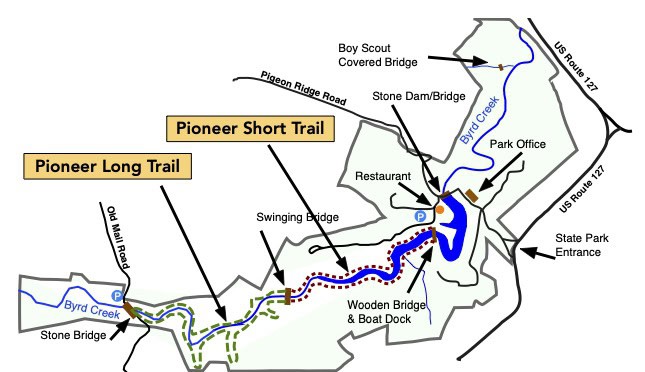
Walk over to the trail head where the Pioneer Trail starts and ends. Turn right and follow the Pioneer Trail along Bryd Creek to the swinging bridge The first leg of the Pioneer Short trail has been recently renovated by an enthusiastic group of volunteers led by Linda Klingerman. It is a pleasure to walk on this section without roots and rocks as trip hazards. Crossover the swinging bridge, turn right and continue along the trail until you reach Old Mail Road. Crossover the stone road bridge and start you return journey. This section of the trail has many exposed roots on the trail so take extra care to avoid turning an ankle. When you reach the swinging bridge, cross over and turn left to head back to trail-head.
11. Windlass Cave, Cumberland Trail
- Distance: 3.0 miles
- Rating: Moderate
- Trailhead GPS Coordinates: 35.870433, -84.929764
Driving Directions
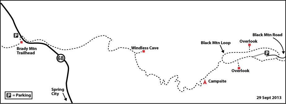
Driving from Crossville: Take route 127 south. At the Homestead Tower leave route 127 and follow route 68 towards Grassy Cove and Spring City. After four miles pass Cox Valley Road on the left. Shortly afterwards identify the Brady Mountain trailhead parking on the right, just a shoulder along Route 68.
Description
Cross the road carefully as the road can be quite busy, and start up the Black Mountain Trail. (Take care not to head south on the Brady Mountain Trail!) Hike the trail steadily uphill for about one and a half miles and turn left to Windlass Cave. The cave itself is closed to the public to protect the bats in the cave itself from the white-nose disease. Take a well-earned rest before turning around and heading back downhill to the trailhead to complete this 3.0-mile hike.